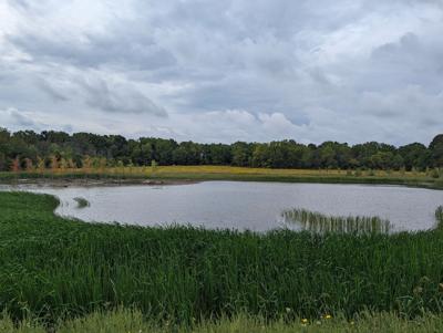
A 38.5-hectare Tapleytown Road property acquired by the Hamilton Conservation Authority is part of a strategy to build wetlands, like the one seen here at the Saltfleet Conservation area’s main hub on First Road East, to reduce flash flooding.
A 38.5-hectare Tapleytown Road property acquired by the Hamilton Conservation Authority is part of a strategy to build wetlands, like the one seen here at the Saltfleet Conservation area’s main hub on First Road East, to reduce flash flooding.
Upper Stoney Creek’s Saltfleet Conservation Area is expanding again with the addition of a fourth property, the final piece of a plan to build wetlands to reduce flash flooding along creeks below the escarpment.
“We’re thrilled,” Hamilton Conservation Authority chief administrative officer Lisa Burnside said of the 38.5-hectare plot of land on the western side of Tapleytown Road by the Dofasco 2000 Trail.
“This finalizes all the land holdings we need to complete the project and build the four wetland complexes.”
ARTICLE CONTINUES BELOW
A mix of farm fields and forest, the 455 Tapleytown Rd. property is the second biggest acquisition, boosting the park’s overall size to more than 166 hectares, or 411 acres.
The site was identified in a 2018 class environmental assessment study that examined ways to reduce flooding of residential and business properties along the lower stretches of Battlefield and Stoney creeks during big rainstorms.
The study estimated creating the four wetlands had the potential to hold back 592,500 cubic metres of stormwater, or enough to fill about 237 Olympic swimming pools.
The authority completed the first two-pond wetland at the Saltfleet park’s largest 72-hectare main hub on First Road East, opened in September 2022.
ARTICLE CONTINUES BELOW
Construction of a second, smaller wetland on a nine-hectare property by the southwest corner of Fifth Road East and Green Mountain Road is expected to begin next summer.
A third wetland is planned at the 20-hectare property of the former Punch Bowl Market on Ridge Road, acquired in June 2022. As with the first two wetlands, it requires an archeological study before moving to the design stage.
Burnside said the authority has the $2 million for the Fifth Road East wetland in place and hopes to once again tap outside funding sources for the remaining two wetlands, including a federal program related to climate change adaptation.
Coun. Brad Clark, who is the authority’s chair and represents upper Stoney Creek, said although the Tapleytown acquisition’s primary goal is to reduce flooding, it also provides more local opportunities to see nature up close.
That’s a welcome development, he said, noting the late Jim Howlett, a former chair who served on the authority board for 17 years, had criticized the authority for focusing too much on the Dundas Valley at the expense of the city’s east end.
“I’m really excited, in that we really didn’t have a lot of conservation areas 20 years ago on Stoney Creek mountain,” Clark said, citing the Eramosa Karst feeder lands as another big addition. “We’ve come a long way.”
Anyone can read Conversations, but to contribute, you should be a registered Metroland account holder. If you do not yet have a Metroland account, you can create one now (it is free).
To join the conversation set a first and last name in your user profile.


Anyone can read Conversations, but to contribute, you should be a registered Metroland account holder. If you do not yet have a Metroland account, you can create one now (it is free).
To join the conversation set a first and last name in your user profile.
Sign in or register for free to join the Conversation